Showing 69 items matching documents - maps/records
-
 Bendigo Military Museum
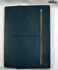
Administrative record - FOLDER, 2) & .3) Geographical Section, General Staff, No 4080 War Office 1941 et al, Navigator's Log Book, 2) & .3) 1941
... documents - maps/records...: Mediterranean. Blue & red ink numerous notations over map. documents ....1) Navigator's Log Book, hard cover, blue colour buckram with dark blue paint on front cover. Back end paper includes a pocket for maps & has a Conversion Table & Nautical Miles, Statute Miles, Kilometres, tables in black print on beige paper included. Stiff card divider. .2) Map folded, black printing on beige paper. Gibraltar Scale 1:1,000,000 at 56 degrees N. .3) Map folded, black printing on beige paper. Algeria Scale 1:1,000,000 at 56 degrees N. .4) Pencil grey lead, timber colour. Stamped into pencil: HB Commonwealth of Australia..1) Hand written in black ink on front end paper: Wreck at Cape Juby. In pencil: S2 / MZ / W2 / 1Z . 35N .2) Hand written in blue pencil: Atlantic. Blue & red ink & lead pencil notations over map. .3) Hand written in blue pencil: Mediterranean. Blue & red ink numerous notations over map.documents - maps/records, military history, passchendaele barracks trust -
 Phillip Island and District Historical Society Inc.
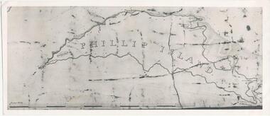
Photograph, Bryant West
One of a collection of over 400 photographs in an album commenced in 1960 and presented to the Phillip Island & Westernport Historical Society by the Shire of Phillip IslandPhotograph of an early Map of Phillip Island not drawn to scale. Copy from Records Office, London.On back of photo - "If used must bear acknowedgement - reproduced by permission of the Hydrographer of the Navy" "Received 18/3/1955 from London Records Office per Mr mcGrigor-Phillips" Printed on Map "Phillip Island"local history, photography, photographs, maritime documents, maps, exploration, john jenner, bryant west, phillip island map -
 Bendigo Military Museum
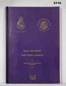
Administrative record - RASvy - Defense Mapping Agency Exchange Officer End of Tour Report MAJ D Bowen 1982, MAJ DH Bowen US Army Corps of Engineers, 3. 5. 1982
A 2 x year personnel exchange program existed between RASvy and the US Army Corps of Engineers. This is the End of Tour Report produced by David H Bowen, Major, Corps of Engineers, US Army Exchange Officer, Australia in 1982A4 Document, Plastic cover, Purple and gold, RASvy Badge emblem and Defense Mapping Agency Badge emblems in gold, 17 pages, 13 enclosures, black and white print, colour photos and mapsReport compiled by David H Bowen, Major, Corps of Engineers, US Army Exchange Officer, Australiaroyal australian survey corps, rasvy, fortuna, army survey regiment, army svy regt, asr -
![Understanding Documents for Genealogy & Local History / [by] Bruce Durie](https://victoriancollections.net.au/media/collectors/550653872162f11fb04854aa/items/5ed04a3cdcf9cd08346b9695/item-media/5ed04b15dcf9cd08346ba396/item-fit-380x285.jpg) Kew Historical Society Inc
Kew Historical Society IncBook, The History Press, Understanding Documents for Genealogy & Local History, 2013
Genealogists and local historians have probably seen every birth, marriage, death and census record available, and are adept at unsing the internet for research. However, once they have learnt everything they can from them, the next step is reading and understanding older documents. These can be hard to find (not many are online), are often written in challenging handwriting and use legal and other unfamiliar terms. Some will be in Latin, antiquated English or Scots. Readers need to be able to understand the nature and intent of a range of documents as well as the palaeography (the handwriting) and orthography (the 'shape' of the contents). Documents covered include wills and testaments, contracts, indentures, charters, land records, personal letters, official records, Church records and others, mainly from the period 1560 to 1800. Also covered are dates, numbers, calendars, measurements and money, abbreviations, transcription conventions, letter-forms and glossaries, and it includes a Latin primer.448 pages : illustrations (black and white) ; 25 cm.Genealogists and local historians have probably seen every birth, marriage, death and census record available, and are adept at unsing the internet for research. However, once they have learnt everything they can from them, the next step is reading and understanding older documents. These can be hard to find (not many are online), are often written in challenging handwriting and use legal and other unfamiliar terms. Some will be in Latin, antiquated English or Scots. Readers need to be able to understand the nature and intent of a range of documents as well as the palaeography (the handwriting) and orthography (the 'shape' of the contents). Documents covered include wills and testaments, contracts, indentures, charters, land records, personal letters, official records, Church records and others, mainly from the period 1560 to 1800. Also covered are dates, numbers, calendars, measurements and money, abbreviations, transcription conventions, letter-forms and glossaries, and it includes a Latin primer.genealogy -- handbooks, local history -- archival resources., genealogy -- archival resources. -
 Tatura Irrigation & Wartime Camps Museum
Document, Record of Life in Camp 1A and 1 B, 1944
Life in an internment campa 35 page record in a plastic folder, clear plastic front and 3 cm black margin left hand side extending to the back cover. Some of the content headlines or places are Orange, Tatura, Long Bay, Melbourne, South Australia. A map and 19 towns of WA, Northern Territory, New Guinea. Reg No is the translation as is the "Tatura Song" written by H. Sturzenhofecker to the melody good cheer comrades, on the horse and Mr Otto Herbst being awarded a certificate commanding of yachts. Written in German "Verzeuhnis Alter Internieiten De Sannellagers Tatura (1A and B) Von 5 Juni - 15 December 1940otto herbst, h. sturzenhofecker, camp 1a and 1b -
Tatura Irrigation & Wartime Camps Museum
Document, Geological Plan, Eildon Dam Site, 1945
To record details of geological aspects of EildonA series of maps illustrating rock formations etc., locations, boundaries and planswater/irrigation, documents, maps -
 Tatura Irrigation & Wartime Camps Museum
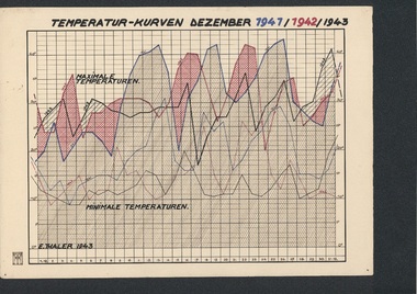
Folio, Loveday & Camp 1 Temperature & Wind records, 1942-45
Records taken and graphed while in internment at Loveday and Tatura. Sketches and story were done in Camp 3, TaturaBlue plastic folder and sleeves containing 10 graphs, and nineteen coloured pen and ink and colour sketches and story of young children in Camp 3ww2 camp 3, loveday, documents, maps -
 Victorian Aboriginal Corporation for Languages
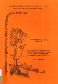
Book, Sue C Wesson, An overview of the sources for a language and clan atlas of Eastern Victoria and Southern New South Wales, 1994
This monograph concerns Eastern Victoria and Southern New South Wales and reviews the ethnographic record available for the study area. A test case is made of one tribe within the study area which requires further research. Overall, the literature review and the case study demonstrate that the ability to undertake detailed reconstructions, as Clark and Barwick have done for the other regions, can be undertaken in Eastern Victoria and Southern New South Wales, and this model will form the basis of future research.maps, b&w illustrations, b&w photographs, document reproductions, tableswoiworung, bunurong, taungurong, ngurai-illam-wurung, bidawal, maap, norman tindale, diane barwick, aldo massola, eve fesl, ian david clark, george augustus robinson, reverend john bulmer, robert brough smyth, alfred william howitt, moieties, clan names -
 Victorian Aboriginal Corporation for Languages
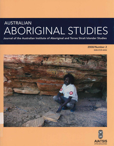
Periodical, Australian Institute of Aboriginal and Torres Strait Islander Studies, Australian Aboriginal studies : journal of the Australian Institute of Aboriginal and Torres Strait Islander Studies, 2008
Mawul Rom Project: Openness, obligation and reconciliation Morgan Brigg (Universtiy of Queensland) and Anke Tonnaer (University of Aarhus, Denmark) Aboriginal Australian initiatives to restore balanced relationships with White Australians have recently become part of reconciliation efforts. This paper provides a contextualised report on one such initiative, the Mawul Rom crosscultural mediation project. Viewing Mawul Rom as a diplomatic venture in the lineage of adjustment and earlier Rom rituals raises questions about receptiveness, individual responsibility and the role of Indigenous ceremony in reconciliation efforts. Yolngu ceremonial leaders successfully draw participants into relationship and personally commit them to the tasks of cross-cultural advocacy and reconciliation. But Mawul Rom must also negotiate a paradox because emphasis on the cultural difference of ceremony risks increasing the very social distance that the ritual attempts to confront. Managing this tension will be a key challenge if Mawul Rom is to become an effective diplomatic mechanism for cross-cultural conflict resolution and reconciliation. Living in two camps: the strategies Goldfields Aboriginal people use to manage in the customary economy and the mainstream economy at the same time Howard Sercombe (Strathclyde University, Glasgow) The economic sustainability of Aboriginal households has been a matter of public concern across a range of contexts. This research, conducted in the Eastern Goldfields of Western Australia, shows how economically successful Aboriginal persons manage ?dual economic engagement?, or involvement in the customary economy and the mainstream economy at the same time. The two economies sometimes reinforce each other but are more often in conflict, and management of conflicting obligations requires high degrees of skill and innovation. As well as creating financially sustainable households, the participants contributed significantly to the health of their extended families and communities. The research also shows that many Aboriginal people, no matter what their material and personal resources, are conscious of how fragile and unpredictable their economic lives can be, and that involvement in the customary economy is a kind of mutual insurance to guarantee survival if times get tough. Indigenous population data for evaluation and performance measurement: A cautionary note Gaminiratne Wijesekere (Dept. of Families, Housing, Community Services and Indigenous Affairs, Canberra) I outline the status of population census counts for Indigenous peoples, identifying information on Indigenous births and deaths, and internal migration estimates. I comment on the ?experimental? Indigenous population projections and question the rationale for having two sets of projections. Program managers and evaluators need to be mindful of limitations of the data when using these projections for monitoring, evaluating and measuring Indigenous programs. Reaching out to a younger generation using a 3D computer game for storytelling: Vincent Serico?s legacy Theodor G Wyeld (Flinders University, Adeliade) and Brett Leavy (CyberDreaming Australia) Sadly, Vincent Serico (1949?2008), artist, activist and humanist, recently passed away. Born in southern Queensland in Wakka Wakka/Kabi Kabi Country (Carnarvon Gorge region) in 1949, Vincent was a member of the Stolen Generations. He was separated from his family by White administration at four years of age. He grew up on the Cherbourg Aboriginal Reserve in the 1950s, when the policies of segregation and assimilation were at their peak. Only returning to his Country in his early forties, Vincent started painting his stories and the stories that had been passed on to him about the region. These paintings manifest Vincent?s sanctity for tradition, storytelling, language, spirit and beliefs. A team of researchers was honoured and fortunate to have worked closely with Vincent to develop a 3D simulation of his Country using a 3D computer game toolkit. Embedded in this simulation of his Country, in the locations that their stories speak to, are some of Vincent?s important contemporary art works. They are accompanied by a narration of Vincent?s oral history about the places, people and events depicted. Vincent was deeply concerned about members of the younger generation around him ?losing their way? in modern times. In a similar vein, Brett Leavy (Kooma) sees the 3D game engine as an opportunity to engage the younger generation in its own cultural heritage in an activity that capitalises on a common pastime. Vincent was an enthusiastic advocate of this approach. Working in consultation with Vincent and the research team, CyberDreaming developed a simulation of Vincent?s Country for young Aboriginal and non-Aboriginal persons from the Carnarvon Gorge region to explore Vincent?s life stories of the region. The use of Vincent?s contemporary paintings as storyboards provides a traditional medium for the local people to interactively re-engage with traditional values. Called Serico?s World, it represents a legacy to his life?s works, joys and regrets. Here we discuss the background to this project and Vincent?s contribution. A singular beeswax representation of Namarrkon, the Lightning Man, from western Arnhem Land RG Gunn (La Trobe University) and RL Whear (Jawoyn Association) Samples from a beeswax representation of Namarrkon, the Lightning Man, from western Arnhem Land were analysed for radiocarbon and dated to be about 150 years old. An underlying beeswax figure was found to be approximately 1100 years old. The Dreaming Being Namarrkon is well known throughout Arnhem Land, although his sphere of activity is concentrated around the northern half of the Arnhem Land plateau. Namarrkon is well represented in rock-paintings in this area and continues to be well represented in contemporary canvas-paintings by artists from the broader plateau region. We conclude that representations of Namarrkon in both painted and beeswax forms appear to be parallel manifestations of the late Holocene regionalisation of Arnhem Land. ?Missing the point? or ?what to believe ? the theory or the data?: Rationales for the production of Kimberley points Kim Akerman (Moonah) In a recent article, Rodney Harrison presented an interesting view on the role glass Kimberley points played in the lives of the Aborigines who made and used them. Harrison employed ethnographic and historical data to argue that glass Kimberley points were not part of the normal suite of post-contact artefacts used primarily for hunting and fighting or Indigenous exchange purposes, but primarily were created to service a non-Indigenous market for aesthetically pleasing artefacts. Harrison asserted that this market determined the form that these points took. A critical analysis of the data does not substantiate either of these claims. Here I do not deal with Harrison?s theoretical material or arguments; I focus on the ethnographic and historical material that he has either omitted or failed to appreciate in developing his thesis and which, in turn, renders it invalid. The intensity of raw material utilisation as an indication of occupational history in surface stone artefact assemblages from the Strathbogie Ranges, central Victoria Justin Ian Shiner (La Trobe University, Bundoora) Stone artefact assemblages are a major source of information on past human?landscape relationships throughout much of Australia. These relationships are not well understood in the Strathbogie Ranges of central Victoria, where few detailed analyses of stone artefact assemblages have been undertaken. The purpose of this paper is to redress this situation through the analysis of two surface stone artefact assemblages recorded in early 2000 during a wider investigation of the region?s potential for postgraduate archaeological fieldwork. Analysis of raw material utilisation is used to assess the characteristics of the occupational histories of two locations with similar landscape settings. The analysis indicates variability in the intensity of raw material use between the assemblages, which suggests subtle differences in the occupational history of each location. The results of this work provide a direction for future stone artefact studies within this poorly understood region.document reproductions, maps, b&w photographs, colour photographskimberley, mawul rom project, 3d computer game, storytelling, vincent serico, beeswax, namarrkon, artefact assemblages, strathbogie ranges, groote eylandt, budd billy ii -
 Victorian Aboriginal Corporation for Languages
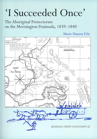
Book, Marie Hansen Fels, I succeeded once : the Aboriginal Protectorate on the Mornington Peninsula, 1839-1840, 2011
1. The writings of William Thomas 2. The Context 3. The record of observation 4. Tubberubbabel, Protectorate head station 5. Kangerong, Protectorate second station 6. Buckkermitterwarrer, Protectorate third station 7. Kullurk, the Bonurong choice for a reserve 8. The raid into Gippsland and the massacres remembered 9. Manufacturing industry on the Mornington Peninsula, 'the successful plan at Arthurs Seat' 10. Death of Johnny and his burial on the foreshore at McCrae 11. The abduction between Arthurs Seat and Point Nepean, and Yankee Yankee's return 12. Thomas' translations.maps, document reproductions, b&w illustrations, colour illustrations, colour photographsboon wurrung, yarra mission, william thomas -
 Victorian Aboriginal Corporation for Languages
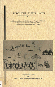
Book, Through their eyes : an historical record of Aboriginal people of Victoria as documented by the officials of the Port Phillip Protectorate, 1839-1841, 1994
maps, b&w illustrations, b&w photographswathaurung, woiworong, woi wurrung, bunorong, boon wurrung, taungurong, taungurung, derrimut, william thomas, port phillip protectorate -
 Victorian Aboriginal Corporation for Languages
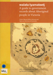
Book, Public Record Office Victoria et al, Walata tyamateetj : a guide to government records about Aboriginal people in Victoria, 2014
... to find relevant records. document reproductions, maps, b&w ...Public Record Office Victoria and the National Archives of Australia hold many government records about Aboriginal people in Victoria. This guide is designed to help Victorian Aboriginal people find records about their family and country. It will also assist anyone researching the history and administration of Aboriginal affairs in Victoria to find relevant records.document reproductions, maps, b&w photographsarchives, archives directories, historical sources, public records, victorian history -
 Kew Historical Society Inc
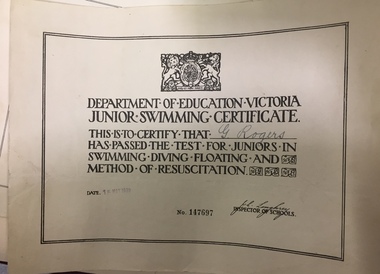
Certificate, Education Department (Victoria), Junior Swimming Certificate, 15/05/1939
This work forms part of the collection assembled by the historian Dorothy Rogers, that was donated to the Kew Historical Society by her son John Rogers in 2015. The manuscripts, photographs, maps, and documents were sourced by her from both family and local collections or produced as references for her print publications. Many were directly used by Rogers in writing ‘Lovely Old Homes of Kew’ (1961) and 'A History of Kew' (1973), or the numerous articles on local history that she produced for suburban newspapers. Most of the photographs in the collection include detailed annotations in her hand.The Rogers Collection provides a comprehensive insight into the working habits of a historian in the 1960s and 1970s. Together it forms the largest privately-donated collection within the archives of the Kew Historical Society.Printed Junior Swimming Certificate. Education Department of Victoria. Awarded to G. Rogers in 1939. The certificate records that the swimmer passed the test for juniors in swimming, diving, floating, and methods of resuscitation. No. 147697. Date: 15 May 1939george rogers, swimming certificates -
 Kew Historical Society Inc
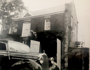
Photograph, J E & B L Rogers, Stables, 'Roseneath', Pakington Street, c.1959
This work forms part of the collection assembled by the historian Dorothy Rogers, that was donated to the Kew Historical Society by her son John Rogers in 2015. The manuscripts, photographs, maps, and documents were sourced by her from both family and local collections or produced as references for her print publications. Many were directly used by Rogers in writing ‘Lovely Old Homes of Kew’ (1961) and 'A History of Kew' (1973), or the numerous articles on local history that she produced for suburban newspapers. Most of the photographs in the collection include detailed annotations in her hand.The Rogers Collection provides a comprehensive insight into the working habits of a historian in the 1960s and 1970s. Together it forms the largest privately-donated collection within the archives of the Kew Historical Society.'Roseneath' was constructed in stages in the I850s by John Ambrose Kitchen, a soap-maker. In 1870 the brick house received an N.A.V. of £60 while in 1885 it was purchased by Edward John Dunn, a geologist. A new wing was built at the right side of the house and several rooms as well as the coach house, loft and groom's quarters were added. In 1903, during Dunn's ownership, the property was described as having eight roorns. The garden is recorded as having been designed by Baron von Mueller who was the Government Botanist from 1853. Source: City of Kew Urban Conservation Study, 1988"32"historic houses -- kew (vic.), roseneath -- pakington street -- kew (vic.) -
 Kew Historical Society Inc
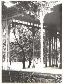
Photograph, 'Ellesmere,' Princess Street, Kew, circa 1965, c. 1960
A National Trust (Vic) citation records that Ellesmore [sic] was: 'A late Victorian Villa in the grand manner but completed to a meaner standard in the Edwardian Period. Notable for the mannerist porticos surmounted by a sepulchre motif: the central vestibule at the intersection of the two major axes, with lantern lighting from above: and the art nouveau woodwork of the drawing room'.This work forms part of the collection assembled by the historian Dorothy Rogers, that was donated to the Kew Historical Society by her son John Rogers in 2015. The manuscripts, photographs, maps, and documents were sourced by her from both family and local collections or produced as references for her print publications. Many were directly used by Rogers in writing ‘Lovely Old Homes of Kew’ (1961) and 'A History of Kew' (1973), or the numerous articles on local history that she produced for suburban newspapers. Most of the photographs in the collection include detailed annotations in her hand. The Rogers Collection provides a comprehensive insight into the working habits of a historian in the 1960s and 1970s. Together it forms the largest privately-donated collection within the archives of the Kew Historical Society.View of the front veranda of Ellesmere in Princess Street (now demolished). Ellesmereellesmere, kew, princess street, dorothy rogers -
 Kew Historical Society Inc
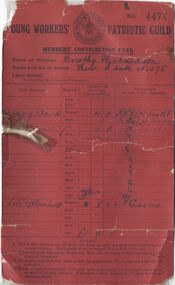
Document, Young Workers Patriotic Guild - Members Contribution Card, No. 4472, 1914-1918
This work forms part of the collection assembled by the historian Dorothy Rogers, that was donated to the Kew Historical Society by her son John Rogers in 2015. The manuscripts, photographs, maps, and documents were sourced by her from both family and local collections or produced as references for her print publications. Many were directly used by Rogers in writing ‘Lovely Old Homes of Kew’ (1961) and 'A History of Kew' (1973), or the numerous articles on local history that she produced for suburban newspapers. Most of the photographs in the collection include detailed annotations in her hand. The Rogers Collection provides a comprehensive insight into the working habits of a historian in the 1960s and 1970s. Together it forms the largest privately-donated collection within the archives of the Kew Historical SocietyA red cash record card used by Dorothy Richardson of Gladstone Street Kew to record donations to patriotic causes in the First World War while a student of Kew Primary School.Dorothy Rogers Kew State No.1075 [etc]young workers patriotic movement, dorothy rogers, kew primary school, first world war (1914-18) -
 Kew Historical Society Inc
Photograph, Floods in North Kew, 1971
Living with natural processes was frequently a challenge to early European settlers and later residents of what was in the 1850s administered by the Borondara Road Board. This was compounded by the area being bounded on three sides by rivers (Yarra River, Koonung Creek and Gardiner's Creek). In 1849, the historian James Bonwick recorded that "our district [Kew] suffered considerably. Mr Wade speaks of 80 acres, out of 100 acres of his cultivated paddock, covered by water." Newspapers continued to describe major flooding in Kew in 1863, 1869, 1878, 1880, 1889, 1891, 1916 and 1934. While the construction of the Upper Yarra dam in 1957 reduced the levels of flowing downstream, local and riverine floods continue.The Kew Historical Society's pictures and map collections testify to the impact of flooding in the district. They have historical importance in documenting the extent of flooding in the district and its affects on homes, services and recreation. Numerous photographs record flooding throughout the Twentieth Century.Floods in North Kew, 1971. Looking northeast towards Kilby Road from River Avenue. Annotation on reverse: map and date "8 Nov. 71 10.30am".floods (kew), yarra river, kew flood, kilby road flood -
 Kew Historical Society Inc
Photograph, Floods in North Kew, 1934
Living with natural processes was frequently a challenge to early European settlers and later residents of what was in the 1850s administered by the Borondara Road Board. This was compounded by the area being bounded on three sides by rivers (Yarra River, Koonung Creek and Gardiner's Creek). In 1849, the historian James Bonwick recorded that "our district [Kew] suffered considerably. Mr Wade speaks of 80 acres, out of 100 acres of his cultivated paddock, covered by water." Newspapers continued to describe major flooding in Kew in 1863, 1869, 1878, 1880, 1889, 1891, 1916 and 1934. While the construction of the Upper Yarra dam in 1957 reduced the levels of flowing downstream, local and riverine floods continue.The Kew Historical Society's pictures and map collections testify to the impact of flooding in the district. They have historical importance in documenting the extent of flooding in the district and its affects on homes, services and recreation. Numerous photographs record flooding throughout the Twentieth Century.Floods in North Kew, 1934. Vicinity of Willsmere Park.floods (kew) -
![Flooding at Chipperfield's Boathouse [East Kew], 1934](https://victoriancollections.net.au/media/collectors/550653872162f11fb04854aa/items/58cbaad5d0cec425b474bfb1/item-media/58cf6fbdd0cf9f331490feb0/item-fit-380x285.jpg) Kew Historical Society Inc
Kew Historical Society IncPhotograph, Flooding at Chipperfield's Boathouse, 1934
Living with natural processes was frequently a challenge to early European settlers and later residents of what was in the 1850s administered by the Borondara Road Board. This was compounded by the area being bounded on three sides by rivers (Yarra River, Koonung Creek and Gardiner's Creek). In 1849, the historian James Bonwick recorded that "our district [Kew] suffered considerably. Mr Wade speaks of 80 acres, out of 100 acres of his cultivated paddock, covered by water." Newspapers continued to describe major flooding in Kew in 1863, 1869, 1878, 1880, 1889, 1891, 1916 and 1934. While the construction of the Upper Yarra dam in 1957 reduced the levels of flowing downstream, local and riverine floods continue.The Kew Historical Society's pictures and map collections testify to the impact of flooding in the district. They have historical importance in documenting the extent of flooding in the district and its affects on homes, services and recreation. Numerous photographs record flooding throughout the Twentieth Century.Floods in North Kew, 1934. Chipperfield's Boathouse and the adding Moorings was located beside the Yarra River near the corner of Willsmere and Kilby Roads. The flood reached the roof of the Moorings, which can be seen in the photo.floods (kew), floods (kew) 1934, yarra river -
 Kew Historical Society Inc
Photograph, Floods in North Kew, 1934
Living with natural processes was frequently a challenge to early European settlers and later residents of what was in the 1850s administered by the Borondara Road Board. This was compounded by the area being bounded on three sides by rivers (Yarra River, Koonung Creek and Gardiner's Creek). In 1849, the historian James Bonwick recorded that "our district [Kew] suffered considerably. Mr Wade speaks of 80 acres, out of 100 acres of his cultivated paddock, covered by water." Newspapers continued to describe major flooding in Kew in 1863, 1869, 1878, 1880, 1889, 1891, 1916 and 1934. While the construction of the Upper Yarra dam in 1957 reduced the levels of flowing downstream, local and riverine floods continue.The Kew Historical Society's pictures and map collections testify to the impact of flooding in the district. They have historical importance in documenting the extent of flooding in the district and its affects on homes, services and recreation. Numerous photographs record flooding throughout the Twentieth Century.Floods in North Kew, 1934. Unidentified location on the Yarra Flood Plain at Kew.floods (kew) 1934, yarra river -
 Kew Historical Society Inc
Photograph, Floods in North Kew, 1934
Living with natural processes was frequently a challenge to early European settlers and later residents of what was in the 1850s administered by the Borondara Road Board. This was compounded by the area being bounded on three sides by rivers (Yarra River, Koonung Creek and Gardiner's Creek). In 1849, the historian James Bonwick recorded that "our district [Kew] suffered considerably. Mr Wade speaks of 80 acres, out of 100 acres of his cultivated paddock, covered by water." Newspapers continued to describe major flooding in Kew in 1863, 1869, 1878, 1880, 1889, 1891, 1916 and 1934. While the construction of the Upper Yarra dam in 1957 reduced the levels of flowing downstream, local and riverine floods continue.The Kew Historical Society's pictures and map collections testify to the impact of flooding in the district. They have historical importance in documenting the extent of flooding in the district and its affects on homes, services and recreation. Numerous photographs record flooding throughout the Twentieth Century.Floods in North Kew, 1934. Chipperfield's Boat House under flood.floods (kew) 1934, yarra river, chipperfield's boat house -
 Kew Historical Society Inc
Photograph, Floods in North Kew, 1934
Living with natural processes was frequently a challenge to early European settlers and later residents of what was in the 1850s administered by the Borondara Road Board. This was compounded by the area being bounded on three sides by rivers (Yarra River, Koonung Creek and Gardiner's Creek). In 1849, the historian James Bonwick recorded that "our district [Kew] suffered considerably. Mr Wade speaks of 80 acres, out of 100 acres of his cultivated paddock, covered by water." Newspapers continued to describe major flooding in Kew in 1863, 1869, 1878, 1880, 1889, 1891, 1916 and 1934. While the construction of the Upper Yarra dam in 1957 reduced the levels of flowing downstream, local and riverine floods continue.The Kew Historical Society's pictures and map collections testify to the impact of flooding in the district. They have historical importance in documenting the extent of flooding in the district and its affects on homes, services and recreation. Numerous photographs record flooding throughout the Twentieth Century.Floods in North Kew, 1934. Flood near the lagoon (Billabong?)floods (kew) 1934, yarra river -
 Monbulk RSL Sub Branch
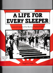
Book, Hugh V Clarke, A life for every sleeper : a pictorial record of the Burma - Thailand railway, 1988
This book is based on documents, photographs and maps preserved in the records of the Australian war memorial, and on the experiences of the author.Ill, p.115.non-fictionThis book is based on documents, photographs and maps preserved in the records of the Australian war memorial, and on the experiences of the author.world war 1939 – 1945 - prisons and prisoners – japanese, burma thailand railway -
 Ballarat Tramway Museum
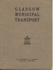
Book, Corporation of Glasgow Transport Department, "Glasgow Municipal Tramway", c1933
Book - 48 pages + 2 fold out maps + cover, card cover, bound, giving details of history of Glasgow tramways, power stations, substations, workshops, bus stations, training and underground railway. Commences at p41 - 92, could have been part of a larger document. Record reviewed and scanned images of cover added 5/9/13. trams, tramways, glasgow, uk, tramway, bus, underground -
Southern Sherbrooke Historical Society Inc.
Book - Local History, Victorian Government Printing Office on behalf of the Government of Victoria, Historical Records Of Victoria, Vol. 3, 1984
pp.xix, 670, paperback book, maps, photos, colour plates, index. A collection of documents concerning the development of Melbourne, Victoria, Australia, compiled by the Public Records Office, Victoria.foundation of melbourne -
 Wodonga & District Historical Society Inc
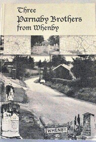
Book - Three Parnaby Brothers from Whenby, Julie Walker and Judy Crook, 2000
This book documents the story of the Parnaby Brothers who migrated to Australia from Whenby in North Yorkshire, England via Natal in South Africa. They settled in the Wodonga district of Victoria. The dedication on page 3 of the book says "To George, William and Matthew Parnaby. We can only wonder at the adventurous spirit, courage and fortitude of the three brothers who arrived in this country with an ambition to better themselves and provide for their families." George arrived at Port Melbourne from Port Natal on 11 January 1864. On the same voyage was his brother William and a nephew Charles. George and his wife Rachel settled at Howlong on the Victoria/NSW border where he worked as a farmer and labourer. George died at Howlong on 26 JUne 1887. William and his son Charles settled in Albury. In 1869/70 he was listed as a property owner at Wooragee, including a house, farm and vineyard. William died in Albury on 20 February 1894. Matthew originally arrived in Hobsons Bay, Victoria in 1854. After 6 years on the goldfields he returned to South Africa and then to England to marry. They eventually returned to Australia in 1863. After some time in Melbourne, Matthew moved to Belvoir (Wodonga). By August 1877 he owned 104 acres of grazing land at House Creek. He steadily became one of the most successful farmers in the district and increased his landholdings. He spent the remainder of his life in Wodonga where he served as a member of the Shire Council for some years. Matthew never forgot his birthplace and called his property "Whenby Grange". He died in Wodonga on 7 October 1903.A volume of 342 pages, including photos and maps. The cover includes images of the town of Whenby, maps and the grave of Matthew Parnaby who died in Wodonga on 7 October 1903.This book documents the story of the Parnaby Brothers who migrated to Australia from Whenby in North Yorkshire, England via Natal in South Africa. They settled in the Wodonga district of Victoria. The dedication on page 3 of the book says "To George, William and Matthew Parnaby. We can only wonder at the adventurous spirit, courage and fortitude of the three brothers who arrived in this country with an ambition to better themselves and provide for their families." George arrived at Port Melbourne from Port Natal on 11 January 1864. On the same voyage was his brother William and a nephew Charles. George and his wife Rachel settled at Howlong on the Victoria/NSW border where he worked as a farmer and labourer. George died at Howlong on 26 JUne 1887. William and his son Charles settled in Albury. In 1869/70 he was listed as a property owner at Wooragee, including a house, farm and vineyard. William died in Albury on 20 February 1894. Matthew originally arrived in Hobsons Bay, Victoria in 1854. After 6 years on the goldfields he returned to South Africa and then to England to marry. They eventually returned to Australia in 1863. After some time in Melbourne, Matthew moved to Belvoir (Wodonga). By August 1877 he owned 104 acres of grazing land at House Creek. He steadily became one of the most successful farmers in the district and increased his landholdings. He spent the remainder of his life in Wodonga where he served as a member of the Shire Council for some years. Matthew never forgot his birthplace and called his property "Whenby Grange". He died in Wodonga on 7 October 1903.parnaby family, whenby england, whenby grange wodonga -
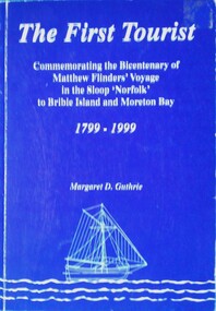 Wodonga & District Historical Society Inc
Book - The First Tourist, Margaret D. Guthrie, 1999
The full title of this publication is "The first tourist: commemorating the bicentenary of Matthew Flinders' voyage in the sloop Norfolk to Bribie Island and Moreton Bay, 1799-1999". It was sponsored by Pacific Harbour, Bribie Island with the assistance of the Regional Arts Development Fund. Although Flinders documented his voyage to Australia in his major work "Voyage to Terra Australia", little mention is made of his voyage to Bribie Island. However this publication claims Matthew Flinders as the first official tourist to Bribie Island. It was published to celebrate the bicentenary of his voyage.A book of 72 pages including plates, maps and illustrations. The cover is blue with white text and an illustration of a sailing sloop. It includes a bibliography.The full title of this publication is "The first tourist: commemorating the bicentenary of Matthew Flinders' voyage in the sloop Norfolk to Bribie Island and Moreton Bay, 1799-1999". It was sponsored by Pacific Harbour, Bribie Island with the assistance of the Regional Arts Development Fund. Although Flinders documented his voyage to Australia in his major work "Voyage to Terra Australia", little mention is made of his voyage to Bribie Island. However this publication claims Matthew Flinders as the first official tourist to Bribie Island. It was published to celebrate the bicentenary of his voyage.matthew flinders, flinders bicentenary, australia - exploration and settlement -
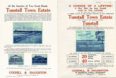 Whitehorse Historical Society Inc.
Legal record - Document, Tunstall Town Estate
Land subdivision at Tunstall 1926 bounded by Springvale Road, Whitehorse Road, Railway Parade.Land subdivision at Tunstall 1926 bounded by Springvale Road, Whitehorse Road, Railway Parade. Original in Haughton Maps LaTrobe LibraryLand subdivision at Tunstall 1926 bounded by Springvale Road, Whitehorse Road, Railway Parade. land subdivision, springvale road, nunawading, railway parade, kelly, j, nunawading state school, no. 4190, shire of blackburn and mitcham, whitehorse road, silver grove, glendale street -
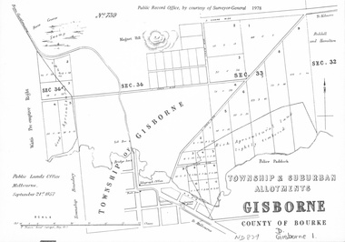 Whitehorse Historical Society Inc.
document - Map, Melbourne Metro, 1978
Collection of reproductions issued by the Public Record Office in 1978. Comprises: Allotments in the Black Forest, 1857; Township of Dandenong, 1856; Township and suburban allotments, Gisborne, 1857; Storing Yard allotments near the Melbourne Wharf, 1854; Town lots near the Railway Terminus, Melbourne, 1863; Parish of Prahran, 1853; Township of Sandridge, 1855; Township of Sunbury, 1857; River Yarra Yarra at the Queens Wharf, 1860.victoria. public record office, black forest, victoria, dandenong, gisborne, melbourne wharf, railway terminus, spencer street, melbourne, prahran, sandridge, sunbury, queens wharf -
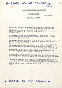 Whitehorse Historical Society Inc.
Legal record - Document, Melbourne Metropolitan Planning Scheme, 1987
Explanatory Statement of Amendment 500 to Melbourne Metropolitan Planning Scheme, including map of area (South of Blackburn Station). To be exhibited from 2 October 1987 to 22 December 1987.roads and streets, victoria. ministry for planning and environment, city of nunawading, south parade, blackburn, blackburn road, blackburn, main street, blackburn